Enviromental Geoinformatics Team
LSGI, Hong Kong Polytechnic University


Environmental Geoinformatics: Employing AI (artificial intelligence) to unravel what previously was unachievable, it is now possible to fully exploit Earth Observation (EO) data for environmental monitoring and applications. The teams' interest is to bring the three multidiscipline (Geoinformatics, Climate, and AI) together, i.e., utilise AI as a powerful computing engine to manipulate EO remotely sensed data (Geoinformatics) and hydroclimate data (climate) to assess, evaluate and understand the impacts of climate extremes, climate variability and climate change on the environment. This includes but not limited to sensing of impacts of climate on stored freshwater (surface, underground, vegetation, and soil moisture) using satellites (GRACE/GRACE-FO, GNSS, Landsat, Sentinel-2, Precipitation and Altimetry, etc), reanalysis (ERA5, MERRA-2, etc) and hydroclimate models (GLDAS, WGHM, AWRA, etc). These satellites, reanalysis and hydroclimate models are employed to face the emerging challenges of the 21st century posed by increased food insecurity and extreme hydroclimatic conditions, e.g., severity and frequency of droughts in Australia and Greater Horn of Africa (GHA), and the changing monsoon characteristics in Asia and Africa leading to floods. Indeed, Africa, Asian and Australian continents are experiencing impacts of climate change that is affecting their water potential and food security, thereby worsening the situation for its inhabitants who rely heavily on rain-fed agriculture. Environmental Geoinformatics, thus enables a wide understanding of natural and human systems using “big data” that is both spatial and temporal in nature. In parallel, the team is engaged in Mathematical Geosciences: Hybrid-symbolic solutions that delivers hybrid symbolic-numeric computations (HSNC), is a large and growing area at the boundary of mathematics and computer science and currently an active area of research. The focus now is to employ AI to solve complex mathematical formulations in geosciences.
Selected Works
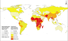 The use of plastic as a household fuel among the urban poor in the Global South Nature Cities (to access read only version of the paper go to https://rdcu.be/eakZC)
 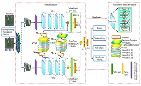 Satellite Image-Based Surveillance and Early Wildfire Smoke Detection Using a Multiattention Interlaced Network IEEE Transactions on Industrial Informatics
 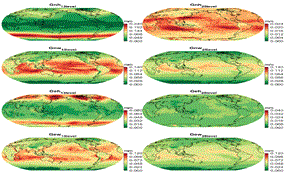 Forecasting of Tropospheric Delay Using AI Foundation Models in Support of Microwave Remote Sensing IEEE Transactions on Geoscience and Remote Sensing
 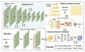 Optimized Landslide Segmentation From Satellite Imagery Based on Multiresolution Fusion and Attention Mechanism IEEE Geoscience and Remote Sensing Letters
 - Optimized Landslide Segmentation From Satellite Imagery Based on Multiresolution Fusion and Attention Mechanism IEEE Geoscience and Remote Sensing Letters
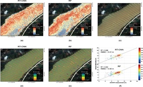 A novel reflectance transformation and convolutional neural network framework for generating bathymetric data for long rivers: A case study on the Bei River in South China International Journal of Applied Earth Observation and Geoinformation
 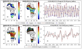 GNSS Radio Occultation Infilling of the African Radiosonde Data Gaps Reveals Drivers of Tropopause Climate Variability Journal of Geophysical Research: Atmospheres
 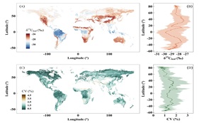 Establishing the global isoscape of leaf carbon in C3 plants through the integrations of remote sensing, carbon, geographic, and physiological informationRemote Sensing of Environment
 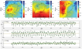 Physical dynamics of Lake Victoria over the past 34 years (1984–2018): Is the lake dying? Science of the Total Environment
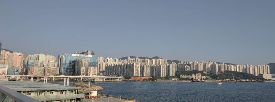
 - Physical dynamics of Lake Victoria over the past 34 years (1984–2018): Is the lake dying? Science of the Total Environment